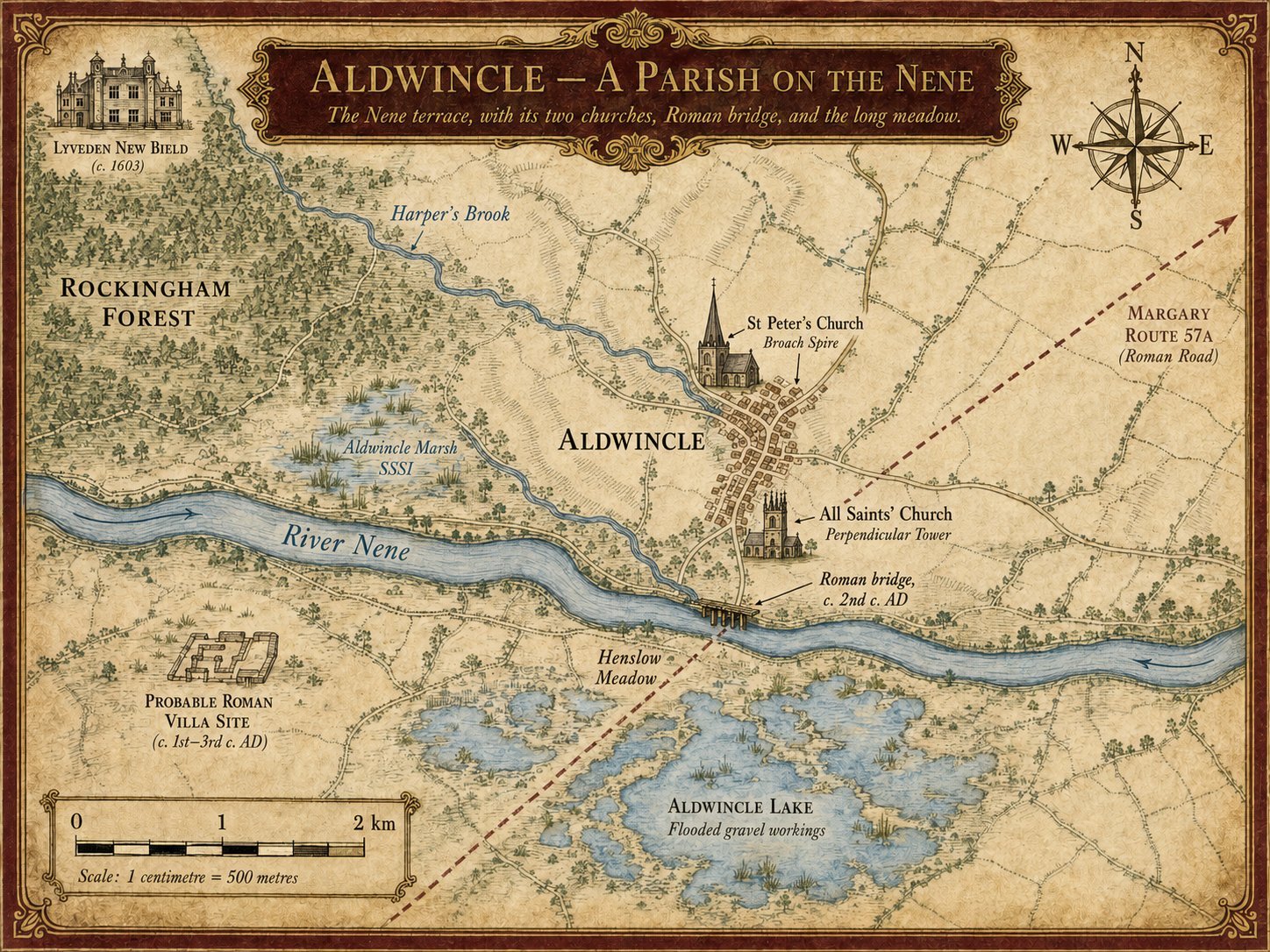
A bend in the Nene
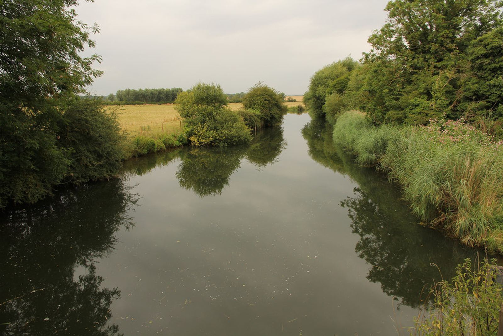
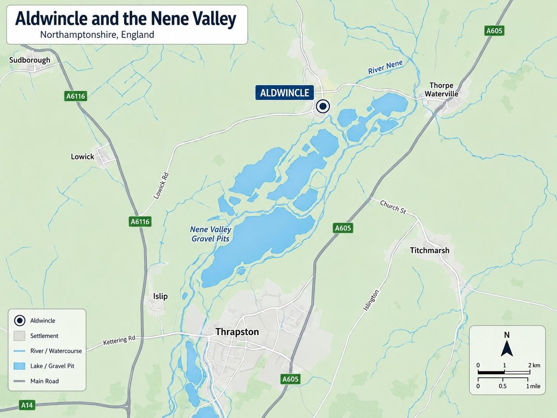
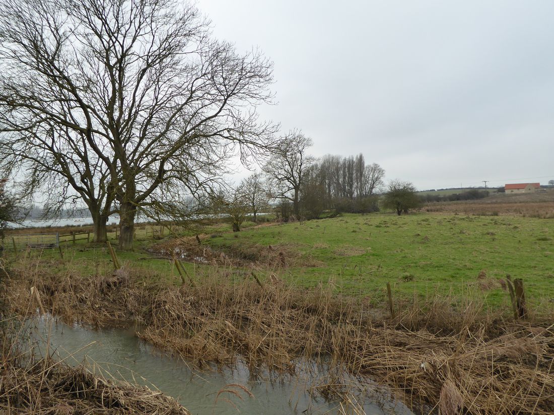
Aldwincle sits where the River Nene curves between the wooded uplands of Rockingham Forest to the west and the fenland edge to the east, on a low terrace of Pleistocene gravels laid down by the river during the long cycles of glaciation and thaw. The same geology that makes the ground well-drained for cultivation and easy to dig for foundations also yielded, in the twentieth century, the commercial sand and gravel that finally exposed the village's deep past. Three forces have supported repeated human activity and settlement here over nearly six thousand years: well-drained terrace gravels, a reliable river crossing, and the joining of a tributary — Harper's Brook — with the main channel just south of the present village.
The parish is small and rural, a little under three thousand acres. The recorded population at the 2021 census was three hundred and thirty-three.1 The Roman engineers who threw a timber bridge across the Nene here in the first or early second century AD chose a crossing point in a landscape that had already seen activity for two thousand years before them. The Anglo-Saxons who founded the village now called Aldwincle settled the same gravel terraces in the post-Roman centuries.
This article distinguishes three categories of historical claim throughout:
Documented — supported by Domesday Book, the Victoria County History (VCH), Historic England, the Northamptonshire HER, published excavation reports, the ODNB, and primary archival sources;
Reasonable inference — Old English place-name interpretation, the landscape logic of river terrace and crossing, general Norman tenurial patterns;
Speculative or unresolved — the personal biography of any putative "Ealda," exact continuity between Roman and Saxon settlement, the precise administrative status of the village under Danish overlordship, and any direct lineal descent from Domesday lords to later families.
Where the text would otherwise blur these lines, the section ends with a short "How certain is this?" panel.
Village centre approx. 52.42°N, 0.51°W · OS National Grid TL 008 815
St Peter's Church at TL 00616 81862 · All Saints' Church at TL 011 815
4 miles (6.4 km) north of Thrapston · North Northamptonshire unitary authority
Before memory
The earliest occupation of the parish is recorded not in any text but in the soil of Henslow Meadow, in the south of the parish near the modern river crossing. Between 1967 and 1971, in advance of commercial gravel quarrying that would soon destroy the site, the archaeologist D. A. Jackson conducted a series of rescue excavations under the sponsorship of the Ministry of Public Building and Works.2 What he uncovered was a continuous prehistoric sequence stretching back almost six thousand years.
A Neolithic mortuary enclosure — one of the earliest forms of monumental burial architecture in Britain, in which the dead were laid out for excarnation before final interment — was traced in plan. Around it, on the same gravel terrace, lay a small group of Bronze Age round barrows, ring ditches, and one extraordinary find: a burial in a coffin shaped like a boat. By the middle of the Iron Age, the site was occupied by an enclosed settlement with a circular hut and twenty-nine pits, dated by its pottery to the second century BC. Pit alignments — ritual or boundary features whose precise function is still debated — ran across the meadow.2
None of this is unusual for the Nene valley. Every comparable terrace gravel site in this part of the East Midlands produces something similar; the river valley was densely occupied by the late prehistoric period. What is important for the village's later history is that the Romans, when they arrived in the first century AD, did not build their road and their bridge into an empty landscape. They built them across one that had already been farmed, mourned in, and lived in for thousands of years.
Documented: Jackson's excavated and published the Neolithic, Bronze Age, and Iron Age features at Henslow Meadow; the dating is solid from associated pottery and stratigraphy.
Probable inference: the gravel terrace was attractive for settlement because it was well-drained and close to fresh water and a river crossing — standard interpretation of comparable Nene-valley sites.
Unresolved: whether occupation was continuous across the three millennia between Neolithic and Iron Age, or punctuated by long gaps. The archaeology shows repeated activity at this spot, not necessarily continuous habitation.
Roman Aldwincle
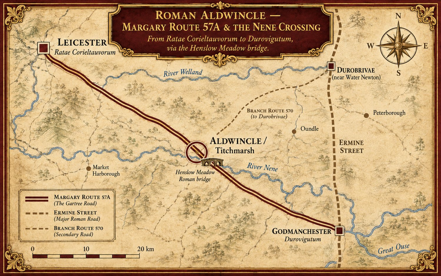
The Roman conquest brought to this stretch of the Nene something the prehistoric period had not: a place on a main imperial road. The road in question is Margary Route 57A, the route from Leicester (Ratae Corieltauvorum) to Godmanchester (Durovigutum), also known locally as Gartree Road.3 It was no minor track. It was one of the engineered cross-country routes of Roman Britain, linking two of the major civitas centres of the East Midlands, and it crossed the River Nene at what is now the south end of Aldwincle parish.
The crossing point was at Henslow Meadow, on the same gravel terrace that had been occupied since the Neolithic. There, in the late autumn of 1968, gravel quarrying exposed in section the unmistakable timbers of a Roman bridge. The working face of the pit had, by coincidence, cut directly along one side of the structure, revealing it to the archaeologists arriving on site.3 Jackson's excavation in the winter of 1968–9 documented three successive timber bridges, rebuilt across the centuries on the same alignment. The river itself has since shifted; what is now the modern Harper's Brook follows the Roman-period course of the Nene.
— Jackson & Ambrose, Britannia 7 (1976), 40
Not just a bridge — a road junction with settlement
What the wider excavations revealed was that the bridge was not an isolated structure crossing an otherwise empty river. It was the surviving infrastructure of a small Romano-British roadside settlement at a road junction.4 A second Roman road branched off northeast from the main Leicester–Godmanchester route, traced over some 500 metres as parallel ditches with surviving limestone-and-gravel metalling. Immediately north of the junction, the soil stripping for the gravel quarry exposed pits, ditches, and probable timber buildings yielding 1st- to 4th-century pottery.5 A probable late Romano-British cemetery lay nearby. Most strikingly, a bronze baldric or horse trapping, characteristically military and of mid-first-century date, was recovered from the body of the road itself — suggesting Roman military traffic on this route in the earliest phase of the conquest, perhaps within years of AD 43.6
A second site, closer to the modern village
Roman occupation was not confined to the river crossing. The Royal Commission's 1975 inventory records a separate Roman site some 700 metres south-west of the present village, at grid reference TL 00308110.7 Surface finds and aerial photography reveal a complex of enclosures and ditches and, scattered across the northern part of the site, a considerable quantity of limestone rubble, large amounts of Roman pottery including imported samian ware and locally-made Nene Valley colour-coated wares, roof and flue tiles, and painted wall-plaster. These materials are consistent with a higher-status Romanised building — flue tiles indicate hypocaust heating, painted plaster indicates finished interior walls — but the site has never been excavated, so its plan, scale, and date range remain unknown. The Royal Commission's own designation is "Roman settlement" rather than "villa." The most defensible description is a probable villa or substantial Romanised farmstead; the surface assemblage is suggestive but not by itself sufficient to prove the full architectural form of a villa.
By the third century, Aldwincle parish contained at minimum: a road-junction with timber settlement and cemetery at the river crossing (Henslow Meadow); a probable villa or higher-status Romanised farmstead near the present village (TL 00308110); and at least two further smaller Roman sites elsewhere in the parish (RCHME items 14, 15). It was a populated, connected, working Romano-British countryside.
Documented: the timber bridge (three phases) on Margary 57A at Henslow Meadow, the adjacent roadside settlement with 1st–4th century pottery, the second road branching north-east, and the bronze military-equipment fragment (all from Jackson & Ambrose 1976, Jackson 1977, Webster 1978).
Probable inference: the TL 00308110 site is most likely a villa or higher-status Romanised farmstead based on the painted plaster, flue tiles, and samian ware — but the site is unexcavated and the designation is RCHME's "Roman settlement."
Unresolved: the full plan and date range of the probable villa; whether any settlement here was occupied directly into the post-Roman period; the precise relationship between Roman Aldwincle and the early Anglo-Saxon material on the same site.
The Anglo-Saxon foundation
When Roman administration withdrew from Britain in the early fifth century, the bridge at Henslow Meadow eventually fell. Whether it fell quickly, in disuse, or slowly, in decay, is not recoverable. What is known — from the same series of excavations — is that within a generation or two, Anglo-Saxon settlers were living in the same place. Sixth-century Anglo-Saxon pottery, an iron loom weight, and a hearth were excavated at Henslow Meadow.8 A possible early Saxon cemetery is recorded at the same location. Most evocatively, a man was buried with an iron knife between his ribs in the eroded surface of the Roman road itself, near the abutment of the now-decayed bridge.
Whether these Anglo-Saxons settled in continuity with a surviving Romano-British community, occupied the standing ruins of one, or arrived after a population gap is not resolvable from current evidence. The point worth holding firmly is the spatial coincidence: the Saxons placed themselves on, or beside, a recognisable Roman landscape, not on virgin ground.
The name and what it suggests
The village name is itself a piece of linguistic evidence. "Aldwincle" is Old English: Ealda (a personal name) + wincel, meaning "nook, corner, secluded place." The standard scholarly reading is "Ealda's nook," though some scholars have proposed the alternative "the old corner" from Old English eald "old."9 Local tradition sometimes associates the wincel element with the great double bend in the river itself, between Thorpe Waterville and Wadenhoe.10
The name's structure is consistent with an early phase of Anglo-Saxon place-naming, roughly the fifth to seventh centuries — earlier than the wave of -tūn and -hām names that proliferated later. But this is a linguistic inference about probable foundation period, not a documentary record. There is no surviving evidence of a specific historical person called Ealda; the name is a reconstructed Old English personal name behind the place-name, not a known individual. The most defensible statement is that the place-name likely originates in the earlier Anglo-Saxon centuries, but the precise date and any biographical detail of an "Ealda" are not recoverable.
Spellings across the centuries
Until the standardisation of English orthography in the eighteenth and nineteenth centuries, place-names — like personal names — were written down phonetically by individual scribes, each using whatever conventions they had learned. A single name could be spelled half a dozen different ways within one document, and once a place's name was clearly recognisable in speech, scribes were under no obligation to settle on a uniform written form. The recorded spellings of Aldwincle trace this slow path from fluid medieval orthography to modern fixity:
| Spelling | Source & date |
|---|---|
| Aldewincla | Peterborough Abbey records, 11th c. |
| Aldevincle, Eldewincle | Domesday Book, 1086 (the two manors' entries) |
| Aldewingel | Peterborough Chronicle, 1137 (continuation of the Anglo-Saxon Chronicle written at Peterborough Abbey) |
| Aldewyncle | 14th-century manorial records (e.g. 1317) |
| Aldwyncle | 15th c. — the spelling on William de Aldwyncle's brass inscription, 1463 |
| Aldwinkle | 18th–19th c. (Bridges, Northamptonshire 1791; Ordnance Survey first edition 1885; Comprehensive Gazetteer 1894) |
| Aldwincle | Modern standardised form (20th c. onwards) |
Further variants encountered in surname and genealogy references, but less securely dated to specific documents, include Aldewinckell, Aldewinkell, Audewinkle, Aldwinckle, Allwinckle, Alwincle, Audewincle, and Aldewynkyl. These should be treated as a list of spellings the name has been written in over the centuries rather than a sequenced documentary record.38
The trajectory in the dated record is consistent with general patterns in English orthography: the dropping of the medial 'e' and final 'a' between the 11th and 15th centuries (Aldewincla → Aldwyncle), and the eventual nineteenth- and twentieth-century replacement of the medieval terminal '-kle' with the Latinate '-cle'.
Surname forms have proved more conservative than the place-name itself. While the village settled on Aldwincle by the twentieth century, the surnames borne by descendants of medieval inhabitants — carried wherever those families moved — preserved older spellings. Aldwinckle (with the medieval 'ck') and Aldwinkle (with the post-medieval 'k') are both still in use by modern families, alongside less common variants. This is a recurring pattern in English surnames: a place may standardise its spelling, but families bearing the name preserve the orthography that was current at the moment their ancestor was first surnamed from it.
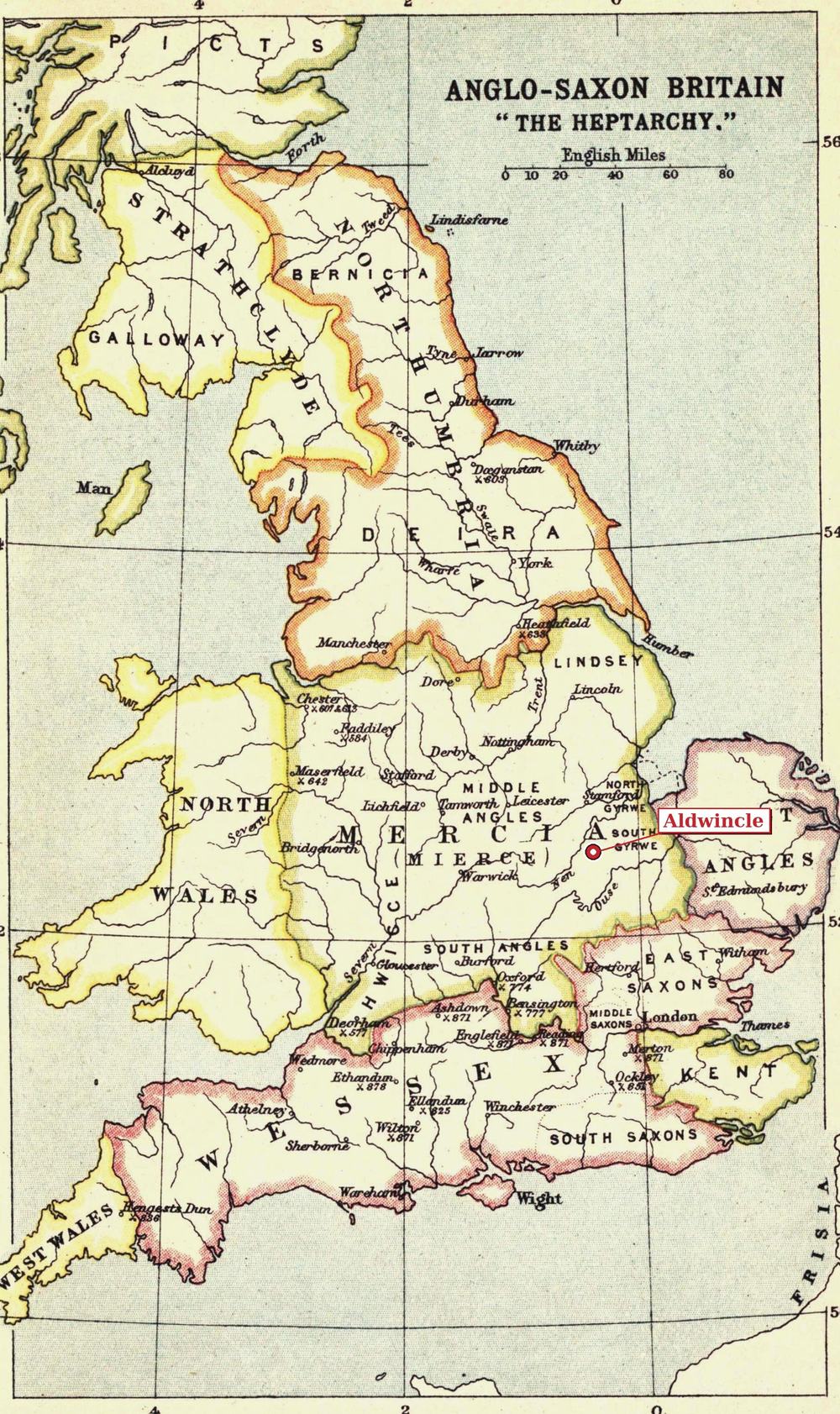
By the seventh century a development took place that would shape this stretch of the Nene valley for the next nine hundred years: the foundation of Medeshamstede — later Peterborough — monastery around AD 655. The new house, dedicated to St Peter, accumulated landholdings rapidly. By the late Anglo-Saxon period it held a substantial portion of Aldwincle itself; the village's later northern manor (Aldwinkle St Peter) is named for the abbey's patron saint, and the church there continues that dedication today.11
Under the Danelaw
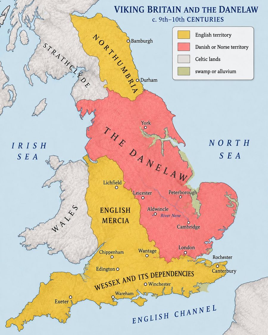
In 870 a Danish army sacked Medeshamstede, slaughtering the monks and burning the monastery — an event recorded vividly in the Anglo-Saxon Chronicle. The regional collapse followed. In the later 870s, after Alfred's victory at the Battle of Edington (878) and the subsequent baptism of the Danish leader Guthrum (traditionally associated with Wedmore), an accommodation between Wessex and the Danish-controlled territories was reached. A more precise boundary, running up the Thames, the Lea, across to Bedford, and along Watling Street (roughly the modern A5), is described in the surviving Treaty of Alfred and Guthrum, datable to c. 880–890.12 Under this arrangement, everything east of the Watling Street line — including the entire Nene valley and Aldwincle — lay within the zone of Danish political influence and control later known as the Danelaw.
The exact administrative status of small villages like Aldwincle under Danish overlordship cannot be reconstructed in detail; surviving documentary evidence for the period is too thin. What can be reconstructed is the place-name evidence of the surrounding landscape, which shows what happened on the ground. Norse settlers established themselves within the existing English agricultural landscape, founding outlying farms and hamlets that took Scandinavian names. The older Anglo-Saxon village names of the river valley persisted. The Danish takeover at this distance from the Danish heartland was, on the available evidence, a political and military overlay rather than a demographic replacement.
Reading the landscape
Within twenty miles of Aldwincle the modern map preserves three distinct linguistic strata:
| Layer | Origin | Visible names |
|---|---|---|
| Anglo-Saxon base | Old English, 5th–9th c. | Aldwincle, Barnwell, Titchmarsh, Islip, Lowick, Thrapston, Clopton, Wadenhoe, Oundle, Wittering, Uppingham, Whittlesey, Weldon, Rothwell, Kettering, Irthlingborough, Wellingborough, Rushden, Ramsey, Sawtry, Huntingdon, Godmanchester |
| Danish overlay | Old Norse, late 9th–10th c. | Corby (Kori's bý); Thorpe Waterville, Thorpe Achurch, Wigsthorpe (hybrid: OE personal name + ON þorp) |
| Norman addition | Norman French, 12th–14th c. | Higham Ferrers, Thorpe Waterville, Burton Latimer, Barton Seagrave |
The pattern is diagnostic. The -thorpe suffix (Old Norse þorp) means specifically a secondary, dependent, or outlying settlement — exactly what new Danish arrivals would establish on the margins of existing English villages. The single -bý name in the area (Corby = "Kori's farm") sits in the north-west, on the high ground above the Welland and Nene watersheds, in what was once Rockingham Forest — consistent with Danish settlement of upland and forested margins rather than prime river-valley sites. The river-valley villages and the fen-island settlements kept their Anglo-Saxon names.13
Aldwincle itself, sitting in the heart of the Danelaw zone of Northamptonshire, kept its Old English name. It was already an established village when the Danes arrived; nothing in the documentary or place-name record suggests the Danish overlordship disturbed its existing structure of fields and tenants.
The Danelaw interlude was brief in political terms. By the reigns of Edward the Elder (899–924) and Æthelstan (924–939), the English kings of Wessex had reconquered the Danelaw and absorbed it into a unified English kingdom. Peterborough Abbey itself was refounded around 966 by Bishop Æthelwold as part of the Benedictine reform movement, and rapidly resumed its position as the major regional ecclesiastical landowner — including its holding at Aldwincle.11
Documented: the Old English origin of "Aldwincle" as a personal-name plus topographic-element compound; the Norse origin of Corby (Domesday Corbei) and the -thorpe satellite names; the 870 sack of Medeshamstede recorded in the Anglo-Saxon Chronicle; the later refoundation of Peterborough Abbey c. 966.
Probable inference: the village probably originates in the earlier Anglo-Saxon period (5th–7th c.) based on name structure; the Danish overlay in this area was thin and additive rather than wholesale; the Danelaw boundary ran along Watling Street based on the Treaty of Alfred and Guthrum.
Unresolved: any biographical detail about a putative founder "Ealda" — the name is reconstructed from the place-name, not from any documentary record. Whether Roman-era settlement continued unbroken into the Saxon period at the same site is also undetermined: the spatial coincidence at Henslow Meadow is real, but stratigraphic continuity is not demonstrated. The administrative arrangements at Aldwincle during Danish overlordship are not recoverable.
Two manors, two churches, one village
By the time the documentary lights come on in 1086 — with the survey of King William's commissioners we now call the Domesday Book — Aldwincle was structured as two distinct manors, recorded separately. The pattern would persist for the next eight hundred years.
| Manor | Hides | 1066 (TRE) | 1086 tenant-in-chief | 1086 lord / sub-tenant |
|---|---|---|---|---|
| Aldwinkle All Saints | 5 | Leofsi (English pre-Conquest landholder; held freely) | Guy of Raimbeaucourt | Landric of Brime, Oger the Breton, and Picot — sharing the holding |
| Aldwinkle St Peter (later Hollands Manor) |
3 | Peterborough Abbey "for the sustenance of the monks" |
Peterborough Abbey (continuing as tenant-in-chief) |
Ferron holding "by the king's command, against the will of the abbot" |
The distinction between tenant-in-chief (the lord who held the manor directly from the king) and local lord or sub-tenant (the man who actually held and ran the manor on the ground) is the key to reading Domesday entries accurately. In the Aldwinkle St Peter entry, Peterborough Abbey remained the tenant-in-chief in 1086 — the manor was still nominally held in chief by the abbey — but the man holding it in possession was Ferron, doing so by royal command and against the abbot's wishes. In the All Saints entry, Guy of Raimbeaucourt was tenant-in-chief, and his three sub-tenants (Landric, Oger, Picot) shared the local lordship.16
It is also worth being precise about Leofsi. The Domesday entry records him as the free pre-Conquest holder of the five-hide All Saints manor; it does not extend to the abbey's separate three-hide holding. He should not be described as having held the whole village before 1066 — only this one manor. The text does not call him a thegn; he is simply an English pre-Conquest landholder recorded as holding the land freely (libere).
This dual-manor structure is the foundation of everything that follows in the village's institutional history. Each manor had its own parish church — All Saints' Church at the southern end of the village, St Peter's Church at the northern end — and each had its own rector, its own glebe, its own advowson (the right to nominate the priest), and its own ecclesiastical governance until the late nineteenth century.14
The Northamptonshire Historic Environment Record notes the unusual feature: "Unusually for Northamptonshire, Aldwinkle single township comprised two separate parishes, each of the two manors having its own church... The two settlements originally seem to have merged in the medieval period."15 Two villages, each with their own church and lord, grew towards each other along what is now Main Street until they became indistinguishable as a single settlement; but the legal and ecclesiastical boundary between them persisted long after the houses had joined up.
Eight hides, thirty-seven households
Across the two manors, Domesday records eight hides of land, plough teams, mills, meadow, and woodland — the standard description of a mixed-farming Anglo-Saxon village. The two holdings break down as follows (figures from Open Domesday):16
| Holding | Households | Plough teams | Other resources | Value 1086 · (1066) |
|---|---|---|---|---|
| Guy of Raimbeaucourt (All Saints) Northants 41,6 · folio 17 |
24 16 villagers, 5 smallholders, 3 slaves |
9 ploughlands 3 lord's teams + 5 men's teams |
meadow 10 acres; woodland 16 × 8 furlongs; 1 mill (6s) | £2 10s (1066 not recorded) |
| Peterborough Abbey (St Peter) Northants 6a,27 · folio 7 |
13 9 villagers, 2 freemen, 2 smallholders |
10 ploughlands 1 lord's team + 4½ men's teams |
meadow 20 acres; woodland 2 × 1 leagues | £1 10s (£1 in 1066) |
| Total | 37 households | 19 ploughlands | in Huxloe hundred | £4 |
What the values say
The "annual value to lord" figure recorded in Domesday is the manor's annual income to its holder — the rent and revenue extracted from the land each year. It is the closest the survey comes to a measure of taxable wealth, distinct from the assessment in hides on which the king's geld was calculated. Three things stand out from the Aldwincle figures.
Peterborough Abbey's holding rose in value by 50% across the Conquest. The St Peter manor was worth £1 to the abbey in 1066 and £1 10s by 1086 — a fifty per cent increase across the twenty years that included the disputed seizure by Ferron, the Conqueror's redistribution of land, and the wider economic dislocations of the period. (Many manors in the survey lost value across the Conquest; Aldwinkle St Peter, despite its disputed tenure, did not.) The 1066 figure for Guy's manor is not recorded in the survey.
Guy's manor was richer per ploughland but poorer per household. Guy's 24 households worked 9 ploughlands and produced £2 10s (5.5 shillings per household; 5.6 shillings per ploughland). Peterborough's 13 households worked more ploughlands (10) for less total value (£1 10s — 2.3 shillings per household; 3 shillings per ploughland). The difference is partly the mill.
The mill was a significant asset. Guy's manor included a watermill on the Nene, recorded at an annual value of 6 shillings — more than 12% of the manor's total £2 10s. Mills were among the most prized infrastructure on a Domesday manor because they could not easily be duplicated and the lord could compel tenants to grind their corn there for a share of the meal. The 6-shilling value of Aldwincle's mill is in the typical range for a small Northamptonshire watermill. Peterborough's manor, larger in cultivated land, did not record a mill — its tenants may have used the neighbouring one or had another arrangement.
The Phillimore references (Northamptonshire 6a,27 and 41,6) and the folio numbers (7 for the abbey holding, 17 for Guy's) allow either entry to be located directly in the manuscript via Open Domesday or any printed edition.16
On the conventional multiplier of around 4.5 persons per household, thirty-seven recorded households implies a real population of perhaps 150 to 170 souls. (Domesday households are heads of households, not a modern population count.) That figure puts Aldwincle firmly in the top twenty per cent of all settlements recorded in Domesday by population. This was not a marginal hamlet; it was a substantial established village.
The Domesday entry for Aldwinkle St Peter is one of the more interesting in the county. The three hides which had belonged to Peterborough Abbey in 1066 were in 1086 held by a man named Ferron praecepto regis super voluntatem abbatis — "by the king's command, against the will of the abbot." The Abbey continued as tenant-in-chief, but had been forced to accept Ferron as the man on the ground. This is a rare documented case of a Norman royal imposition on church land, contested in writing in the survey itself. It is a small window into the early post-Conquest tension between William's reshuffling of estates and the established rights of the great Anglo-Saxon monastic houses.
Who was Guy of Raimbeaucourt?
The new tenant-in-chief of the All Saints manor in 1086 was a man named Guy of Raimbeaucourt, whose surname most likely refers to Raimbeaucourt, a village near Douai in what is now northern France (the historic borderland between Flanders and Picardy). His extensive Northamptonshire fee is documented as a post-Conquest tenancy in Sanders's standard reference work on the post-Conquest baronies, and his name is catalogued in Keats-Rohan's prosopography of Domesday-era persons.17 Beyond his appearance as a tenant-in-chief in Domesday and his name's geographic association with Raimbeaucourt, biographical detail is thin; he is not securely placed at Hastings or otherwise reconstructed in primary documentation. Below him at Aldwincle, three sub-tenants — Landric (of Brime), Oger (the Breton), and Picot — shared the local lordship of the manor.

Documented (from Domesday and VCH): the two-manor structure of eight hides and 37 households; Leofsi as the free pre-Conquest holder of the All Saints manor; Peterborough Abbey as TRE and 1086 tenant-in-chief of the St Peter manor; Ferron's seizure of the abbey's land by royal command; Guy of Raimbeaucourt as 1086 tenant-in-chief of the All Saints manor; Landric, Oger, and Picot as his sub-tenants.
Probable inference: the two-manor split predates the Conquest; the two churches were built in the late Anglo-Saxon period as the focal points of their respective manors; the village formed by the gradual physical merger of two adjacent settlements along what is now Main Street.
Unresolved: the precise date and circumstances of the original split between the two manors; Leofsi's social rank (the text calls him neither thegn nor freeman in any specific way beyond "held freely"); the personal biography of Guy of Raimbeaucourt beyond his Domesday tenure; any direct lineal descent from these eleventh-century landholders to later families.
The medieval centuries
The disputed seizure of Peterborough Abbey's manor recorded in 1086 — with Ferron holding by royal command while the abbey remained tenant-in-chief — was not allowed to stand indefinitely. By around 1125, the position of the abbey on the ground had been restored, with a new lay tenant holding from the abbey rather than against the abbot. The agent of the restoration was a major regional Norman landholder, Ascelin de Waterville — whose family, taking their name from Vatteville (or Watteville) in Normandy, claimed the hereditary high stewardship of Peterborough Abbey itself. By 1155 Ascelin's son or heir Hugh de Waterville had reached a formal composition with Abbot Martin, holding the manor at a rent of sixty shillings and four pence.18
The same Waterville family held neighbouring Thorpe — which from this point became Thorpe Waterville — and Achurch, in a cluster of estates around a single tenurial centre. This is the moment when the linguistic palimpsest of the local landscape received its third stratum: Norman manorial families re-naming places after themselves on top of the existing Anglo-Saxon and Danish base, creating compound names like Thorpe Waterville (Old Norse + Norman) that still appear on the modern Ordnance Survey map.
The de Aldwinkle family
By the mid-thirteenth century, a knightly family had emerged who took their surname from the village itself — the standard medieval pattern by which lords of a manor adopted the manor's name as their family designation. Their descent through six generations is preserved in the Victoria County History of Northamptonshire, Volume 3 (pp. 164–173), reconstructed from feet of fines, patent rolls, close rolls, and inquisitions post mortem.19
| Year | Family head | Notes |
|---|---|---|
| 1242–3 | Henry de Aldwinkle | mesne tenant, the first of the name |
| c. 1270 | Richard, son of Henry | |
| 1280–4 | Henry | held half a knight's fee |
| 1313–17 | Richard | granted the advowson of St Peter's to Robert de Holand in 1316 — origin of the alternative name "Hollands Manor" |
| 1351 | Henry | conveyed lands to Adam Bacoun as trustee |
| 1376 | John | |
| 1427–35 | William | held a fourth part of a knight's fee in Churchfield; received lands from Felbrigge in 1434–5 |
| 1463 | William de Aldwyncle, esq. | died 28 August 1463 — last of the male line in the surname |
The line in the surname ended with the last William, who died on 28 August 1463. His memorial brass survives in the chancel of All Saints' Church — a tangible, datable, visitable monument to the family that took its name from the village (Historic England NHLE 1191528).20 The brass shows him standing in the long civilian gown of a fifteenth-century esquire, hands clasped in prayer, with one foot resting on a small dog at his feet — the conventional symbol of fidelity on medieval funerary brasses.
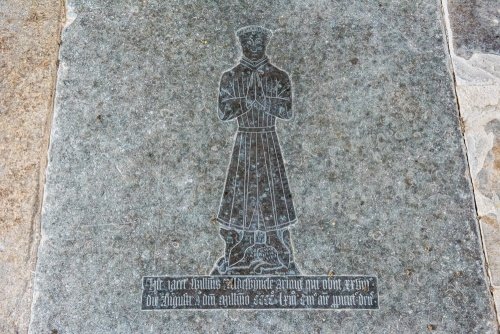
His widow Elizabeth subsequently married William Chambre. In 1488–9 a chantry chapel was founded in the church for prayers for the souls of the dead — the Historic England listing names Elizabeth Chambre herself as the founder, suggesting that the once-widow of William de Aldwyncle was now also commissioning a chantry of her own. The Chambre chantry chapel of 1488–9 still stands as the south chapel of All Saints', one of the finest small chantry chapels of late Perpendicular date in the county.21
The heir to the de Aldwinkle estate was a kinsman, Thomas Lenton — bearing a different surname. The male line in the name was finished. But the village name had outlived three successive ruling cultures — Saxon, Danish, Norman — and would outlive at least three more.
— VCH Northamptonshire III, 168
Tudor hands
The descent of Hollands Manor (Aldwinkle St Peter) after 1463 is documented year by year through the patent rolls and inquisitions post mortem. The list reads like a roll-call of the early Tudor aristocracy:
| Year | Holder | Identification |
|---|---|---|
| 1487 | Margaret Beaufort, Countess of Richmond | mother of King Henry VII; founder of Christ's and St John's Colleges Cambridge; tomb in Westminster Abbey. Held the manor for life. |
| 1487 | Sir John Risley | "the king's servant"; granted the reversion in tail male, including woodland called Bareshanke and meadow in Brantsey and Swillyngholt |
| 1509 | Sir John Risley (succeeds on Margaret's death) | Margaret Beaufort died 29 June 1509, weeks after her grandson Henry VIII's coronation |
| 1513 | Sir William Compton | Henry VIII's groom of the bedchamber and intimate childhood companion; granted the manor in fee by the king after Risley died without a male heir |
| 1528 | Peter Compton (a minor) | inherits aged six |
| 1539 | Henry, later Lord Compton | |
| 1570 | Thomas Cecil | eldest son of William Cecil, Lord Burghley — Elizabeth I's great minister. Created Earl of Exeter in 1605. |
| 1605–1773 | Cecil Earls of Exeter | nine successive earls hold the manor with the earldom |
| 1773 | Thomas Powys of Lilford | conveyed by the ninth Earl; Powys created Baron Lilford 1797 |
The roll-call is, in its way, a compressed history of Tudor and Stuart England. Margaret Beaufort, holding the manor for life from 1487 to 1509, sits at the founding moment of the Tudor dynasty — her son Henry VII having taken the throne at Bosworth two years before her grant. Sir William Compton, granted the manor by Henry VIII in 1513, was one of the king's closest companions, raised with him from boyhood. The Cecil earls of Exeter — the elder branch of the great Burghley dynasty — held the manor through one hundred and sixty-eight years that covered the Civil War, the Commonwealth, the Restoration, the Glorious Revolution, the Act of Union, the South Sea Bubble, and the Hanoverian succession. Aldwinkle St Peter's manor passed quietly through all of it as one estate among many in their portfolio.22
Lyveden and the Treshams
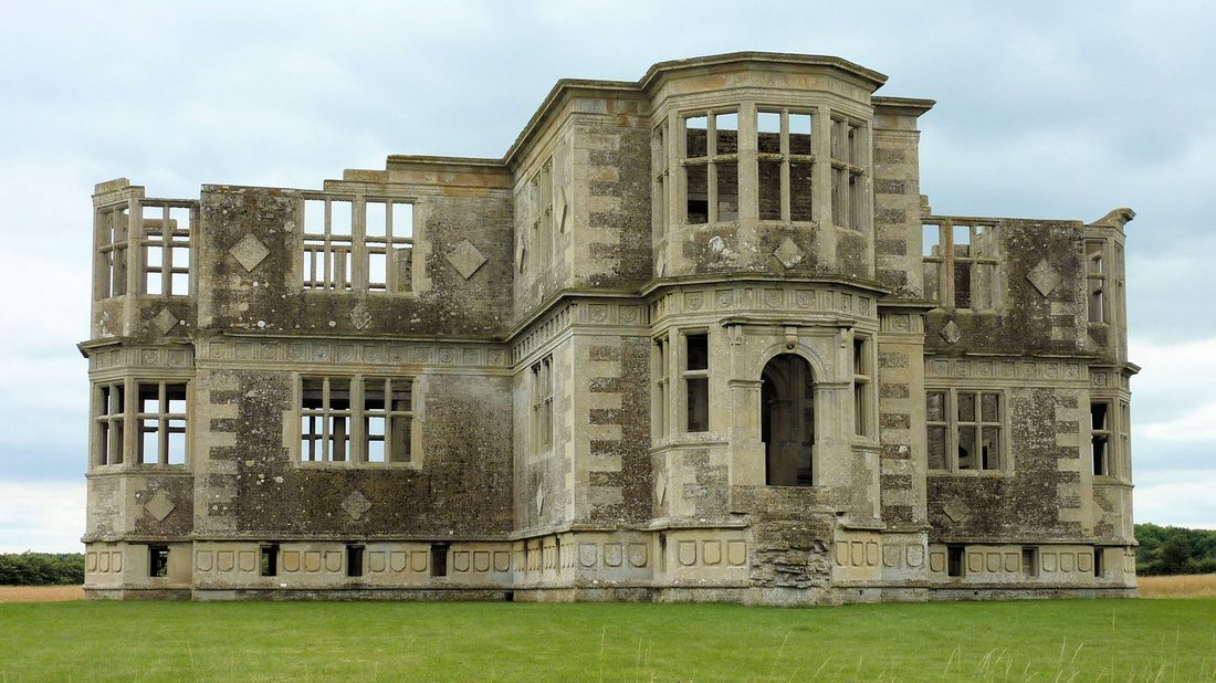
Within the historic parish of Aldwinkle St Peter lies an outlying estate to the north-west of the village: Lyveden, partly held of Peterborough Abbey by two distinct fees (the Bassingbourne fee and the Angevin fee of Churchfield).23 From the mid-fifteenth century to the mid-seventeenth, Lyveden was held by the Treshams of Rushton — one of the most prominent Northamptonshire Catholic recusant families, whose story arcs straight through some of the most famous events of the period.
An earlier Sir Thomas Tresham — controller of King Henry VI's household — was beheaded as a Lancastrian in 1461 after the Yorkist victory at the Battle of Towton. The Lyveden estate passed through complicated reversions until it was restored to the family under Henry VII. It is, however, his grandson Sir Thomas Tresham the younger who is most relevant to the village's history. A devout Roman Catholic, mystic, and famously imprisoned multiple times for recusancy under Elizabeth I, he used his time in confinement to design three extraordinary buildings encoding Catholic numerology and symbolism: the Triangular Lodge at Rushton (a meditation on the Trinity, every dimension a multiple of three); the Market House at Rothwell; and, on the Aldwinkle parish estate, Lyveden New Bield.24
Begun around 1594, Lyveden New Bield was conceived as an equal-armed cross-shaped lodge encoding the numbers of the Passion (3, 5, 7, and 9). The Victoria County History describes it: "the basement windows and shields are grouped in threes; the bay windows have five sides of five feet long; the lower cornice carries seven emblems of the Passion placed in rotation; in the upper cornice were appropriate legends, parts of which remain, and they were so selected that those on each arm had eighty-one letters (nine times nine)."
Sir Thomas Tresham died in 1605 before the building was completed. Within months his son Francis Tresham was implicated in the Gunpowder Plot, arrested, and died in the Tower of London. The Tresham estates were forfeit to the Crown. Lyveden New Bield has stood as a roofless shell — unfinished, exactly as Tresham left it on the day work stopped in November 1605 — ever since. The National Trust acquired it in 1922 and protects it from the weather but has never attempted to complete it.
Three worthies and the Civil War
The decades on either side of the English Civil War are the moment when Aldwincle, a village of perhaps five hundred souls, produced three figures of national importance. All were born at one or other of the two rectories within a span of twenty-three years. The connecting thread was the active Puritan and learned-clerical culture of east Northamptonshire in the early seventeenth century — of which the Aldwincle rectories were a notable local node.
Thomas Fuller
Eldest son of Thomas Fuller senior, rector of Aldwinkle St Peter's from 1602. His uncle and godfather was John Davenant, Bishop of Salisbury. Attended Queens' College Cambridge from age 13, MA at 20. Royalist army chaplain during the Civil War; after the Restoration made chaplain to Charles II shortly before his death in 1661. Author of the History of the Worthies of England (1662, posthumous), one of the founding works of English biographical writing.
Charles Fleetwood
Civil War Parliamentary general; married Bridget Cromwell (Oliver Cromwell's daughter and Henry Ireton's widow) in 1652; Lord Deputy of Ireland 1652–1655; member of Cromwell's Council of State; one of the most senior figures of the Interregnum. After Cromwell's death he commanded the army that briefly held London against the Restoration in 1659. Died in retirement 1692.
John Dryden
England's first official Poet Laureate (appointed 1668); dominant literary figure of the Restoration and Augustan ages; translator of Virgil; satirist, dramatist, critic. His maternal grandfather, Henry Pickering, had been rector of All Saints for forty years until his death in 1637; Pickering's gravestone is preserved inside the church to this day. Dryden was the eldest of fourteen children of Erasmus Dryden and Mary Pickering — Puritan landowning gentry. Educated at Westminster School and Trinity College Cambridge.
That all three came from the same village rectories within a single generation is striking. The Drydens (Sir Erasmus Dryden, 1st Baronet, the poet's paternal grandfather) were Puritan landowning gentry who supported the Puritan cause and Parliament.25 The Pickerings — Henry Pickering as rector of All Saints, his son Sir Gilbert Pickering as Lord Chamberlain to Cromwell — were a leading Northamptonshire Puritan family. Through his cousin Sir Gilbert, the young Dryden obtained his first London position under Cromwell's Secretary of State John Thurloe; at Cromwell's funeral in November 1658 Dryden walked in the procession alongside the Puritan poets John Milton and Andrew Marvell. The Pickering–Dryden–Fleetwood nexus places Aldwincle squarely inside the Cromwellian political and intellectual world.25
The Civil War touches the village
The Civil War itself reached Aldwincle parish directly, though not in a major battle. Around 1655, Major-General Butler — the Parliamentary commander for the Northamptonshire region — attempted to demolish the Tresham manor house at Lyveden, in retaliation for the family's Catholicism and Royalism. He failed structurally, the VCH records, but he "was only able to take the timber, which he carried to Oundle to be used for the house there afterwards belonging to Major Creed."26 The Lyveden New Bield, the unfinished cross-shaped lodge, was apparently considered too remote or too ruined to bother demolishing — and so survives.
At the Restoration in 1660, the Lyveden estates were granted by the Crown to Edward, Earl of Sandwich; the property was then claimed by Maurice Tresham, son of Thomas, and in 1661 he and the earl were jointly enfeoffed. The complicated subsequent descent through eighteenth-century intermediate holders ultimately delivered Lyveden into the hands of the Fitzpatrick Earls of Upper Ossory, and then in 1859 into the new barony of Vernon, created Baron Lyveden.27
Restoration to Regency
The hundred and fifty-five years from the Restoration in 1660 to the end of the Napoleonic Wars in 1815 are, in Aldwincle's documentary record, the quietest period of the modern village's history. No new families of national importance were born here. No battles passed through. The Cecil earls of Exeter held Hollands Manor as one estate among many, leaving the day-to-day administration to local stewards. The Anglican rectors of the two parishes continued their separate ministries. The population, like that of most English villages in this period, oscillated within a narrow band.
Three changes nevertheless deserve attention.
The Lilford acquisition, 1773
On 13 George III, part 19, no. 7 — a date in the Close Roll of 1773 — Henry Brownlow Cecil, ninth Earl of Exeter, conveyed the manor of Aldwinkle St Peter to Thomas Powys of Lilford.28 Powys's principal seat was Lilford Hall, a few miles to the south of Aldwincle. He was created Baron Lilford in 1797. The acquisition consolidated the Powys family's position as the dominant landowner in this stretch of the Nene valley, and the patronage of the living — the right to nominate the rector — passed with the manor. By the late nineteenth century the 1894 Comprehensive Gazetteer would describe the living as "in the gift of Lord Lilford."
The first Lord Lilford pulled down the old timber-framed rectory of St Peter's at the end of the eighteenth century. A new rectory would be built on the same site in 1867, in the Victorian Gothic Revival manner.29
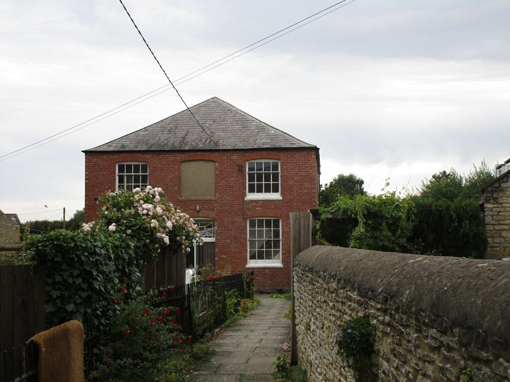
The Baptist Chapel, c. 1823
The third change of this period belongs not to the gentry but to the village's religious nonconformist tradition. Around 1823, on the west side of Main Street between the two Anglican churches, the local Baptist congregation built itself a permanent chapel.30
From the outside, the chapel looks almost domestic. The Historic England listing describes it precisely: "Red brick with slate roof. Single-unit chapel with vestibule and gallery. Main front is two-storey, three-window range of sash windows, with glazing bars, under shallow brick arch. Centre window at first floor is blind. Central panelled double doors with decorative overlight also under shallow brick arch. Hipped roof. Side elevations are similar two-window ranges. Interior: gallery with panelled front, staircase has stick balustrade. Panelled pulpit. Memorials: various nineteenth-century inscribed tablets, earliest dated 1826."31
It is a textbook example of a Georgian Nonconformist village chapel — deliberately understated, built in the plain classical idiom that Dissenting congregations adopted in the late eighteenth and early nineteenth centuries as a deliberate visual contrast to the Gothic and ceremonial style of the established church. The building was listed Grade II on 31 July 1987 (NHLE 1371890).
The 1823 chapel did not arrive from nowhere. Aldwincle's Puritan substrate ran deep: the Pickering family of rectors, the Dryden family of Puritan baronets, Charles Fleetwood the Cromwellian general. The 1662 Act of Uniformity forced clergy who would not conform to the restored Anglican order out of their livings — the "Great Ejection" — and east Northamptonshire was one of the heartlands of the resulting Nonconformist movement. The Northamptonshire Baptist tradition is one of the most important in England: William Carey, the "father of modern Protestant missions," was a shoemaker-pastor at Moulton (just outside Northampton) before founding the Baptist Missionary Society in 1792. The 1823 chapel building probably represents the moment when a congregation that had been meeting informally for some time — perhaps a generation, perhaps a century — finally had the resources and confidence to put up a permanent meeting-house.
The All Saints manor house demolished, c. 1826
Around 1826, the medieval manor house of Aldwinkle All Saints — which had stood immediately east of the churchyard, in an earthwork enclosure visible to this day — was demolished. The Northamptonshire Historic Environment Record (Monument 2285) preserves the evidence: "At the centre of All Saints' lay the church and rectory, and manor-house. The house is depicted immediately east of the churchyard in 1816, though by then realigned askew to the earthwork enclosure surrounding it. It was demolished in c. 1826."15 The earthwork enclosure remains as a grassed feature beside the churchyard. By the early Victorian period, the two manors of Aldwincle existed essentially on paper, with no separate manor houses surviving in either parish.
The two parishes become one
By the middle of the nineteenth century, the dual-parish structure that had defined Aldwincle for nine hundred years was becoming financially and administratively impractical. Two separate parochial establishments — two rectors, two glebes, two sets of churchwardens, two sets of parish registers, two sets of poor relief accounts — were sustainable when the village had been growing, but unsustainable when, like most English villages in this period, its population was stagnant or in slow decline. The 1894 Comprehensive Gazetteer recorded the combined population as 455 across both parishes — little changed from a century before.32
The administrative resolution came in two stages, six years apart.
The ecclesiastical merger, 1879
In 1879, the two ecclesiastical parishes of Aldwincle All Saints and Aldwincle St Peter were formally united under a single rector.14 The merger was driven by demographic pressure and consolidated by the Lilford patronage: a single patron controlling both livings made unification administratively obvious. St Peter's was chosen as the working parish church; All Saints, the older and architecturally finer building but in worse structural condition, would gradually fall out of regular use over the following decades.
The civil amalgamation, 25 March 1885
Six years later, the same merger was extended to civil administration. By a Local Government Order dated 25 March 1885, the civil parishes of Aldwinkle All Saints and Aldwinkle St Peter were formally amalgamated into a single civil parish of Aldwinkle.33 From this date the village had a single rector, a single set of registers, a single parish council, and a single set of administrative boundaries. The institutional consolidation of the village — begun in the medieval period when the two settlements physically merged along Main Street — was finally complete.
Victorian restoration of the churches
The same decades saw substantial Victorian restoration of both Anglican church buildings, in the manner typical of the period:
By the end of the nineteenth century, the village had:
- A single rector serving both churches
- A new Victorian rectory at St Peter's
- Both medieval churches restored to Victorian taste
- An active Baptist congregation with their c. 1823 chapel on Main Street
- A patronage held by Lord Lilford
- An administrative status as a single civil parish in the Northern division of the county, in the hundred of Huxloe, petty sessional division and union of Thrapston, rural deanery of Higham Ferrers, archdeaconry of Oakham, diocese of Peterborough.32
Three churches on Main Street
Walking south to north through the village today, you trace English religious history in compressed form. Within a few hundred metres of each other along Main Street stand three church buildings, all still extant, all listed, representing three distinct strands of English Christianity that took shape across nine centuries.

All Saints' Church
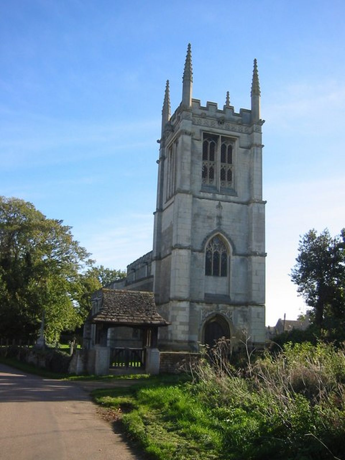
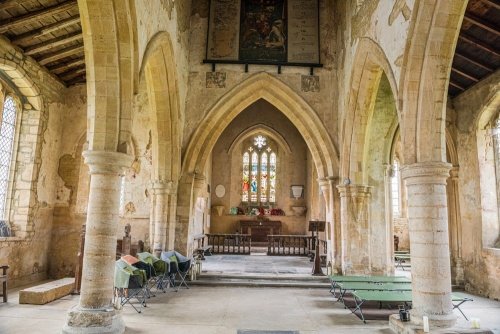
The southernmost of the three. The medieval parish church of the secular lay manor, holding the brass of William de Aldwyncle (1463) and the Chambre chantry chapel of 1488–9. North aisle, vestry, and clerestory added in the 14th c.; tower, porch, and chapel in the 15th c. Restored 1863 and 1893. Declared redundant 1971 and vested in the Churches Conservation Trust. Open to visitors as an "architectural museum"; no regular worship. NHLE 1191528.
Aldwincle Baptist Church
The middle of the three, on Main Street's west side. Red brick with slate roof, hipped, in the plain classical Georgian Nonconformist idiom. Single-unit chapel with vestibule and gallery; panelled pulpit; nineteenth-century memorials. So domestic in appearance that it reads on a satellite map as a house. Earliest memorial tablet dated 1826. Listed Grade II on 31 July 1987. NHLE 1371890. Still an active congregation.
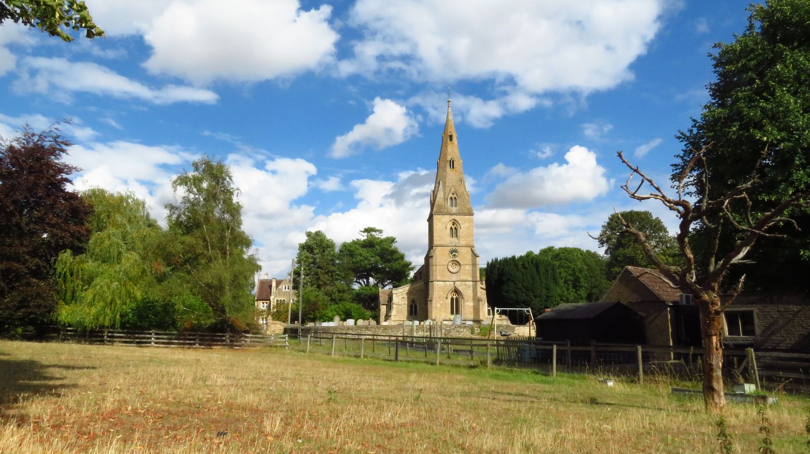
St Peter's Church
The northernmost, with a broach spire. The medieval parish church of the monastic manor, founded on land held by Peterborough Abbey "for the sustenance of the monks" and named for the abbey's patron saint. Earliest fabric c. 1180–90. Chancel rebuilt c. 1370–75; tower, spire, and clerestory of the same period. Restored 1860 and 1876. The active Church of England parish church of the village from 1879 to today; in the Diocese of Peterborough. Holds medieval glass including figures of Roger Travers (rector) and William de Luffwyck (rector and builder of the chancel, 1335–80).
Read together, the three buildings encode a triple stratification of English religious history.
All Saints is the church of the medieval secular manor — the church the de Aldwinkle family knew, where their dead lie under brasses and where William Chambre founded his chantry chapel in 1488 in the assured confidence that prayers for the dead released souls from purgatory. It is medieval English Catholicism's parish church, continuing as the lay manor's church through the Reformation and beyond, finally surplus to a depopulating village by 1971.
St Peter's is the church of the medieval monastic manor — the institution that the seizure of 1086, the restitution of 1125, the composition of 1155, and the survival through the Dissolution all turn on. Named for the saint to whom Peterborough Abbey was dedicated, it is the church of the eight-hundred-year ecclesiastical landholding that the Reformation could redistribute but not erase. After 1879 it became, by administrative consolidation, the single Anglican parish church of the whole village.
The Baptist Chapel is the church of post-Reformation Dissent — descended from the Puritan culture of the early seventeenth century, of which the Pickering rectorship and the Dryden baronetcy were notable local expressions; institutionalised by the Great Ejection of 1662 and the 1689 Act of Toleration; built in brick in 1823 in the wave of Nonconformist chapel-building that swept rural England between 1790 and 1840.
The institutional history of English Christianity, encoded in three buildings on a single village street.
Modern Aldwincle
The twentieth and twenty-first centuries did not, on the whole, bring drama to Aldwincle. They brought, rather, a slow series of consolidations: the consolidation of the parish, the consolidation of agriculture, the consolidation of the church estate, and the consolidation of the landscape into something now valued more for what it once was than for what it currently produces.
The Lyveden preservation, 1922
In 1922, the National Trust acquired Lyveden New Bield — the unfinished cross-shaped lodge that Sir Thomas Tresham had been building when he died in 1605. The Trust protected the walls against the weather, but did not attempt restoration. The building stands today exactly as Tresham left it on the day the work stopped in November 1605, when his son Francis was implicated in the Gunpowder Plot. It is one of the most evocative architectural ruins in England: not a ruin by accident, but a building that has been a ruin from the moment it was built.34
Gravel quarrying and archaeology, 1960s–1990s
From the 1960s onwards, the Pleistocene terrace gravels of the Nene floodplain south of the village were systematically extracted by the construction-aggregate industry. The pits were dug; the gravel was carted away to feed postwar motorway construction and housebuilding; and when extraction stopped, the pumps were turned off and the holes filled with groundwater and Nene river water. The pits became, in succession, lakes.
The same quarrying campaign uncovered, in the late autumn of 1968, the Roman timber bridge at Henslow Meadow. D. A. Jackson's rescue excavations between 1967 and 1971 documented the bridge and the surrounding road, settlement, cemetery, prehistoric monuments, and Anglo-Saxon material before the gravel beneath them was removed. The published reports remain the principal source for everything we now know about the deep past of the parish.35
The resulting lake complex — covering roughly 35 km along the Nene floodplain from near Northampton down to Thorpe Waterville — was, after extraction ceased, deliberately landscaped as wetlands rather than backfilled to agriculture. The complex is now the Upper Nene Valley Gravel Pits, designated a Site of Special Scientific Interest, a Special Protection Area under the EU Birds Directive (2011), and a Ramsar wetland site of international importance. The largest single sheet of water in the Thrapston stretch is called Aldwincle Lake. The adjacent smaller water is the Heronry Lake, supporting a major grey heron colony. The whole complex is managed in part by the Wildlife Trust for Bedfordshire, Cambridgeshire and Northamptonshire.36
Aldwincle Marsh — a smaller SSSI
Distinct from the much larger gravel-pit SSSI is Aldwincle Marsh, a tiny but ecologically important 2-hectare site of marsh and fen on shallow peat, designated a biological Site of Special Scientific Interest in 1984.39 The marsh sits on the geological boundary between the limestone uplands of Rockingham Forest to the west and the clay of the Nene floodplain, and is fed by seepage where the two strata meet. The waterlogged conditions support a fen flora that is increasingly rare in lowland England: blunt-flowered rush, marsh pennywort, wild angelica, and most notably Menyanthes trifoliata — the rare bogbean, a strikingly handsome plant whose pink-fringed white flowers rise above the water on a bare stalk in May. The drier margins support grasses and herbs that draw butterflies and dragonflies in summer.
The site includes a short stretch of Harpers Brook, the same tributary that joins the Nene just south of the village and that has watered the parish since prehistory. Aldwincle Marsh is private land with no public access, but the Nene Way long-distance footpath runs along its eastern boundary, so the marsh can be glimpsed and its character appreciated from the path.
The redundancy of All Saints, 1971
In 1971, under the Pastoral Measure 1968, All Saints' Church was formally declared redundant. The combined parish's working church had been St Peter's since the 1879 merger; All Saints had been used decreasingly through the twentieth century. The redundancy declaration recognised the long-existing reality. All Saints was vested in the Churches Conservation Trust (then known as the Redundant Churches Fund), which has cared for it ever since.37 The CCT keeps the building open to visitors as one of its "architectural museums"; the church holds occasional services but is not in regular liturgical use.
The school, 1976
In 1976, Aldwincle Trinity Church of England Primary School opened. The "Trinity" name folds together the village's two-saint Anglican heritage and the contemporary educational reality of a single rural school serving a population of around three hundred and thirty across Aldwincle and its hinterland.
The village today
Population (2011 census): 322. Population (2021 census): 333.
Civil parish: Aldwincle. Unitary authority: North Northamptonshire.
Working parish church: St Peter's (Diocese of Peterborough). Active Nonconformist congregation: Aldwincle Baptist Church. Preserved redundant church: All Saints (Churches Conservation Trust).
Primary school: Aldwincle Trinity (opened 1976). Village pub and shop: active. Major heritage neighbour: Lyveden New Bield (National Trust).
The village's population today is, within a small margin, what it was in 1086 — perhaps slightly less. Eight hides of land then; roughly the same eight hides of agricultural land (and now, additionally, several hundred hectares of flooded gravel pit) now. Two churches then; three churches now. A Roman bridge then in the south of the parish, surviving as the substructure of the postwar gravel pits; and at the centre of it all, on the same gravel terrace where someone called Ealda made a clearing in the post-Roman centuries, a continuous village called by his name for at least twelve hundred years.
Where to find the images
Three photographs and three maps are now embedded in this page; a few placeholders remain where images are still to be sourced. Before this page is published, the copyright status of each image must be cleared. The table below records the current status of every image used.
| Image | Source | Status |
|---|---|---|
| Hero rotation (3 images, crossfading) | 1. Nene river: Richard Croft, geograph.org.uk #4169399 2. St Peter's church: Wikimedia / geograph #7379870 3. Lyveden New Bield: Wikimedia, July 2016 | Cleared — all CC BY-SA 2.0 (verify two photographer names on Wikimedia file pages before publishing) |
| Nene Valley locator map | Your own work | Cleared — your own creation |
| Parish landscape map | Generated for this site (ChatGPT-4o image generation, May 2026) | Cleared — generated for this project |
| Roman roads map | Generated for this site (ChatGPT-4o image generation, May 2026) | Cleared — generated for this project |
| Heptarchy map (with Aldwincle marker added) | Late 19th-c. English atlas (public domain) + your marker overlay | Cleared — PD historical source, marker added by you |
| Viking Britain & Danelaw map | Your own work | Cleared — your own creation |
| All Saints' interior | Britain Express (David Ross) | Permission needed before publication |
| William de Aldwyncle brass | Britain Express (David Ross) | Permission needed before publication |
| Local landscape map | Your own work (OS-grid plotted) | Cleared — your own creation |
| Roman roads map | Your own work | Cleared — your own creation |
| Domesday tenure map | Your own work (from Open Domesday) | Cleared — your own creation |
| Baptist Chapel | Wikimedia Commons / Geograph #6669485 | Cleared — CC BY-SA 2.0 (verify photographer name on Wikimedia file page) |
| St Peter's Church | Wikimedia Commons / Geograph #7379870 | Cleared — CC BY-SA 2.0 (verify photographer name on Wikimedia file page before publishing) |
| Lyveden New Bield | Wikimedia Commons — Lyveden New Bield July 2016.jpg | Cleared — CC BY-SA (verify photographer name on Wikimedia file page before publishing) |
The All Saints interior and the brass photograph both come from Britain Express, a commercial site run by David Ross. They are used here in the draft so you can see the layout, but they are not freely licensed. Before aldwincle.org goes live you should either: (a) email David Ross via britainexpress.com to request permission — he often grants it for non-commercial heritage use with a credit and link; (b) replace them with Creative Commons alternatives from the Wikimedia Commons category; or (c) photograph the church and brass yourself on a visit (the Churches Conservation Trust keeps All Saints open to visitors). Your own photograph of the brass would also be a better resolution than the one shown.
Wikimedia Commons — the central hub
The single most useful starting point is the Wikimedia Commons category for Aldwincle, which collects 71 free-to-use photographs across three sub-categories:
- commons.wikimedia.org/wiki/Category:Aldwincle — village in general (71 files)
- All Saints' Church (14 files, exterior and interior)
- St Peter's Church (8 files)
- Lyveden New Bield (43 files, multiple angles and the famous garden earthworks)
Specific recommendations by section
| Section | Image needed | Source recommendation |
|---|---|---|
| Setting / Hero | A landscape view of the village, ideally from the south or south-east, taking in the river meadows and the church towers | Geograph #3271603 (David Purchase, 2012) — "All Saints church, Aldwincle" CC BY-SA 2.0 · attribution required |
| Medieval (the brass) | A photograph of the actual William de Aldwyncle brass — the SVG illustration on the page is artistic, not photographic | No CC-licensed photograph appears to exist as of writing. Best route: contact the Churches Conservation Trust (visitchurches.org.uk) who care for All Saints' — they may have a photo file, or arrange a visit. The Monumental Brass Society (mbs-brasses.co.uk) may also hold a rubbing on record. |
| Three Churches × 3 | One exterior photograph of each of the three church buildings | All Saints': Geograph #3271603 or any from the Wikimedia category. Baptist Chapel: search Geograph "Aldwincle Baptist" — limited but extant. St Peter's: 8 options in the Wikimedia Commons category, including good exterior shots showing the broach spire. |
| Tudor (Lyveden) | One image of Lyveden New Bield's cross-shaped lodge, ideally showing the unfinished walls against open sky | Best of 45 options on Wikimedia Commons. Suggest: "Lyveden New Bield across the moat" — geograph.org.uk image #2028524, which captures the building reflected in the moat (CC BY-SA 2.0). |
| Modern (Aldwincle Lake) | A landscape view across the flooded gravel pits / Titchmarsh Nature Reserve | Multiple Geograph results for "Titchmarsh Nature Reserve" or "Aldwincle Lake" — most under CC BY-SA 2.0. Birdwatchers' photographs in winter (low light, mist) work particularly well aesthetically. |
The licence requirement
Geograph and Wikimedia Commons images are almost all under Creative Commons Attribution-ShareAlike 2.0 (CC BY-SA 2.0). To use them legally you must:
- Credit the photographer by name
- State the licence (e.g. "CC BY-SA 2.0")
- Link back to the original source where practical
- License any derivative works (e.g. cropped/edited versions) under the same CC BY-SA terms
The placeholders on this page show this credit pattern. Copy the format and replace the placeholder with the actual <img> tag and credit when the photo is dropped in.
Other image possibilities worth investigating
- Historic maps: the National Library of Scotland's historic Ordnance Survey maps are out of copyright before about 1900 and are freely downloadable. The first-edition 1885 six-inch sheet of this area would be a perfect period inset.
- Domesday Book: Open Domesday at opendomesday.org shows the actual surviving Latin text — they grant use of the page-image scans under generous terms.
- The Roman bridge excavation: photographs from D. A. Jackson's 1968–9 excavation may exist in the archive of the Northamptonshire Historic Environment Record. Request from the HER officer.
- Aerial photography: Britain from Above holds 95,000 free-to-view Aerofilms aerial photos taken 1919–2006, some of which cover this stretch of the Nene valley.
- The Pickering and Dryden families: National Portrait Gallery images of John Dryden (NPG 1133, oil by Sir Godfrey Kneller c. 1683) are out of copyright and available at high resolution.
Sources and footnotes
The footnotes below correspond to numbered references in the text. Where possible the citations point to printed scholarly editions or the relevant digitised primary source; where the underlying record is in The National Archives or the Northamptonshire Record Office, the archival reference is given for the researcher to follow up directly.
- Office for National Statistics, 2011 and 2021 Census, civil parish of Aldwincle; "Aldwincle," Wikipedia, accessed May 2026.
- D. A. Jackson, "The Excavation of Neolithic and Bronze Age Sites at Aldwincle, Northants, 1967–71," Northamptonshire Archaeology 11 (1976), 12–70; D. A. Jackson, "Further Excavations at Aldwincle in Northamptonshire 1969–71," Northamptonshire Archaeology 12 (1977), 9–54.
- D. A. Jackson and T. M. Ambrose, "A Roman Timber Bridge at Aldwincle, Northamptonshire," Britannia 7 (1976), 39–72; quotation from p. 40. For the Margary numbering see I. D. Margary, Roman Roads in Britain, 2nd edn (London: John Baker, 1967).
- Northamptonshire Historic Environment Record, Monument record 2285 (Aldwincle); Royal Commission on the Historical Monuments of England (RCHME), An Inventory of the Historical Monuments in the County of Northampton, Volume I: Archaeological Sites in North-East Northamptonshire (London: HMSO, 1975), entry for Aldwincle.
- Northamptonshire HER, Monument 2433/0/2, "Possible Romano-British Timber Buildings, Henslow Meadow"; RCHME 1975, p. 5, site 10.
- G. Webster, "A Fragment of Roman Military Equipment from Aldwincle," Northamptonshire Archaeology 13 (1978), 169.
- RCHME 1975, item 13, at grid reference TL 00308110.
- D. A. Jackson, "Further Excavations at Aldwincle in Northamptonshire 1969–71," Northamptonshire Archaeology 12 (1977), 47–54.
- A. H. Smith, English Place-Name Society Survey of Northamptonshire, entry for Aldwincle; Family Names of the United Kingdom (FaNUK), 2016, entry "Aldwinckle."
- "Aldwincle, All Saints Northamptonshire," Northamptonshire Surprise heritage guide, retrieved May 2026.
- For Peterborough Abbey see E. King, Peterborough Abbey 1086–1310: A Study in the Land Market (Cambridge: Cambridge University Press, 1973); J. Sparke, Historiae Anglicanae Scriptores Varii (Hugo Candidus); Chronicon Petroburgense (Camden Society).
- For the Danelaw, the Edington/Wedmore tradition, and the Treaty of Alfred and Guthrum see, among many possible sources, F. M. Stenton, Anglo-Saxon England, 3rd edn (Oxford: Oxford University Press, 1971); D. M. Hadley, The Northern Danelaw: Its Social Structure, c. 800–1100 (London: Leicester University Press, 2000); for the surviving text of the Treaty of Alfred and Guthrum (the boundary description used here), see English Historical Documents I, ed. D. Whitelock (London, 1955), no. 34.
- K. Cameron, English Place-Names, 4th edn (London: Batsford, 1996); EPNS Survey of Northamptonshire, relevant entries; for Corby see Domesday entry Corbei; for Northamptonshire Norse names see B. Cox, The Place-Names of Northamptonshire.
- "Aldwincle," Wikipedia; Comprehensive Gazetteer of England and Wales, 1894–5, entry for Aldwinkle All Saints and Aldwinkle St Peter; Wikishire entry for Aldwincle.
- Northamptonshire HER, Monument record 2285 (Aldwincle), accessed via her.northamptonshire.gov.uk.
- Open Domesday (opendomesday.org), entries for Aldwincle [All Saints and St Peter], hundred of Huxloe: Peterborough Abbey holding at Phillimore reference Northamptonshire 6a,27 (manuscript folio 7); Guy of Raimbeaucourt's holding at Phillimore reference Northamptonshire 41,6 (manuscript folio 17). Site by Anna Powell-Smith; Domesday data created by Professor J.J.N. Palmer and team. Cross-referenced against the Victoria History of the County of Northampton, Vol. 3, ed. William Page (London, 1930), pp. 164–173.
- I. J. Sanders, English Baronies: A Study of their Origin and Descent, 1086–1327 (Oxford: Clarendon Press, 1960), p. 33; K. S. B. Keats-Rohan, Domesday People: A Prosopography of Persons Occurring in English Documents 1066–1166, I: Domesday Book (Woodbridge: Boydell, 1999), entry "Guy de Reinbuedcurt."
- VCH Northamptonshire III, 168–173, citing British Library Cotton MS Cleopatra C ii, fol. 236; Chronicon Petroburgense (Camden Society).
- VCH Northamptonshire III, 164–173, reconstructed from Feudal Aids IV, 13; Feet of Fines, The National Archives CP25/1–2; Patent Rolls (TNA C66); Close Rolls (TNA C54); Inquisitions Post Mortem (TNA C132 ff.).
- Historic England, National Heritage List for England, entry 1191528: "Church of All Saints, Aldwincle."
- "All Saints Church, Aldwincle," Wikipedia, citing the Historic England listing and the Churches Conservation Trust description; "Aldwincle, All Saints Northamptonshire," Peterborough Diocesan website.
- VCH Northamptonshire III, 168–173, citing Cal. Pat. 1485–94 pp. 155, 210; Letters and Papers of Henry VIII 1509–13, nos. 1662(58), 2772(51); Complete Peerage (New Edn) iii, 390; Patent Roll 12 Eliz. pts. 7 and 9; Feet of Fines Northants. Hilary 13 Eliz.; Close Roll 13 Geo. III pt. 19 no. 7; G. E. C., Complete Peerage v, 80.
- VCH Northamptonshire III, 170–171; Pytchley's Book of Fees (Northamptonshire Record Society), 73, 120.
- J. A. Gotch, The Buildings of Sir Thomas Tresham; VCH Northamptonshire III, 168–170; Historical Manuscripts Commission Reports (Rushton MSS.); for biographical context see ODNB entries for Thomas Tresham (1543–1605) and Francis Tresham.
- Oxford Dictionary of National Biography (ODNB), entries on John Dryden, Thomas Fuller, Charles Fleetwood, Sir Erasmus Dryden 1st Bt., Sir Gilbert Pickering 1st Bt.; "Aldwincle All Saints," Peterborough Diocesan churchcrawler entry.
- VCH Northamptonshire III, 170, citing John Bridges, The History and Antiquities of Northamptonshire, II (1791), 373.
- VCH Northamptonshire III, 170–171, citing Patent Roll 12 Chas. II pt. 24 m. 12; Calendar of State Papers Domestic 1660–1, 351, 367; Feet of Fines Northants. Trin. 13 Chas. II; G. E. C., Complete Peerage.
- VCH Northamptonshire III, 169, citing Close Roll 13 Geo. III pt. 19 no. 7; G. E. C., Complete Peerage v, 80 (Lilford).
- VCH Northamptonshire III, 168, citing Associated Architectural Societies Reports vii, 251.
- Aldwincle Baptist Church c. 1823, listing description; Northamptonshire Baptist Association historical records; for the wider Northamptonshire Baptist context, see B. R. White, The English Baptists of the 17th Century, rev. edn (Didcot: Baptist Historical Society, 1996).
- Historic England, NHLE entry 1371890: "Aldwincle Baptist Church," listed Grade II on 31 July 1987.
- Comprehensive Gazetteer of England and Wales, 1894–5, entry for Aldwinkle All Saints and Aldwinkle St Peter (combined); reproduced at ukga.org.
- Forebears, Northamptonshire genealogy resources, entry for Aldwincle, citing the Local Government Order of 25 March 1885 amalgamating the two civil parishes.
- National Trust property records, Lyveden New Bield; Historic England NHLE listing for Lyveden New Bield (Grade I).
- Jackson 1976 and 1977 (as cited at notes 2 and 8 above); Jackson and Ambrose 1976 (note 3); Webster 1978 (note 6).
- Natural England SSSI citation, Upper Nene Valley Gravel Pits; Ramsar Information Sheet, Upper Nene Valley Gravel Pits; Wildlife Trust for Bedfordshire, Cambridgeshire and Northamptonshire, Titchmarsh Nature Reserve management plan.
- "All Saints Church, Aldwincle," Wikipedia and Churches Conservation Trust listing; Historic England NHLE 1191528.
- For Aldwincle spelling variants see A. H. Smith, EPNS Survey of Northamptonshire, entry for Aldwincle; primary spellings drawn from Domesday Book (Open Domesday entries for Aldwinkle All Saints and Aldwinkle St Peter); the Peterborough Chronicle continuation 1070–1154 (ed. Cecily Clark, The Peterborough Chronicle, Oxford 1958/1970); the VCH Northamptonshire III, 164–173; J. Bridges, The History and Antiquities of Northamptonshire, II (1791), 373; Ordnance Survey, first-edition six-inch sheet, 1885. Less securely dated genealogical variants compiled from various surname-history sources should be treated as leads rather than primary documentary attestations.
- Natural England, Designated Sites View: Aldwincle Marsh, SSSI citation, notified 1984, grid reference TL 004 807, biological interest (designatedsites.naturalengland.org.uk, site code S1002551); summary at en.wikipedia.org/wiki/Aldwincle_Marsh.
- Architectural dates and description for St Peter's, Aldwincle: Historic England listing NHLE 1040308 (Grade I, listed 23 May 1967); summary information drawn from the parish website (St Peter's Church Aldwincle, achurchnearyou.com); and architectural-history sources including Britain Express, all consistent in dating the north aisle to c. 1180–90, the spire and chancel to c. 1370–75, and the south aisle to c. 1520.
Primary archival sources worth pursuing further
For deeper research the following collections at the National Archives and the Northamptonshire Record Office (NRO) contain the documentary substructure of much of the above:
- TNA: Feet of Fines CP25/1–2 (medieval property transactions); Patent Rolls C66 (royal grants and confirmations); Close Rolls C54; Inquisitions Post Mortem C132 ff. (records of deaths and inheritances of significant landholders); Wards and Liveries Inquisitions; Calendar of State Papers Domestic.
- NRO: Lilford / Powys family papers (the dominant source for 18th–19th-century manorial and parish administration); Aldwincle parish registers (Aldwinkle All Saints baptisms 1813–1889; Aldwinkle St Peter baptisms 1813–1889 and earlier where surviving); Bishop's transcripts.
- British Library: Cotton MS Cleopatra C ii (fol. 236, Peterborough Abbey 12th c. survey); Harley Charters.
- Buccleuch MSS, Boughton House: charters relating to Great and Little Lyveden (nos. 53–58), referenced in the VCH for the Lyveden tenants.
- Cambridge University Library: Chronicon Petroburgense (Peterborough Chronicle) for the abbey's 12th-century landholding survey.
Standard scholarly references
- William Page (ed.), The Victoria History of the County of Northampton, Volume 3 (London, 1930), pp. 164–173 (the two manor entries); pp. 168–173 (St Peter and Lyveden); pp. 164–168 (All Saints).
- RCHME, An Inventory of the Historical Monuments in the County of Northampton, Volume I: Archaeological Sites in North-East Northamptonshire (HMSO, 1975).
- I. J. Sanders, English Baronies: A Study of their Origin and Descent, 1086–1327 (Oxford, 1960).
- K. S. B. Keats-Rohan, Domesday People I: Domesday Book (Boydell, 1999).
- I. D. Margary, Roman Roads in Britain, 2nd edn (London: John Baker, 1967).
- A. H. Smith, English Place-Name Society Survey of Northamptonshire.
- J. Bridges, The History and Antiquities of Northamptonshire, ed. Peter Whalley, 2 vols (Oxford, 1791).
- G. E. C[okayne], The Complete Peerage (revised edition).
- Oxford Dictionary of National Biography (online), entries for the relevant individuals.